Modeling Urban Sprawl for the Master Plan of Tikrit City Using Geo-AI and the CA-Markov Model
- Safaa Adel Jumaa Khalaf , Department of Geography and GIS, College of Arts, University of Tikrit, Iraq
- Manhal Abdullah Hammadi Taama , Department of Geography and GIS, College of Arts, University of Tikrit, Iraq
Article Information:
Abstract:
This study aims to model urban expansion within the master plan of Tikrit city by leveraging Geospatial Artificial Intelligence (Geo-AI) and the CA-Markov model. The primary objective is to analyze urban growth dynamics and forecast future trends for the period (2024–2044). The research is predicated on an analysis of Land Use and Land Cover (LULC) changes in Tikrit between 2000 and 2024, utilizing GLC-FCS30D data with a 30-meter spatial resolution.The methodology integrates Geo-AI techniques via the Google Earth Engine (GEE) platform with the CA-Markov model, which effectively synthesizes Markov Chains' temporal change probability analysis with Cellular Automata’s (CA) capacity for simulating spatial interaction and urban sprawl. Several spatial drivers influencing expansion—such as proximity to roads and rivers, as well as elevation and slope derived from the SRTM Digital Elevation Model—were incorporated due to their direct impact on directing urban growth patterns.The findings indicate that Tikrit has experienced significant urban expansion over the past decades. Projections suggest continued growth at an accelerating pace toward the north, northwest, and west, particularly along the Baghdad-Mosul highway. This trend is attributed to the availability of developable land, minimal physical constraints, and strong connectivity to the primary transportation network. Furthermore, predictive maps for 2034 and 2044 demonstrate persistent urban pressure on the city's peripheries, with built-up areas increasingly encroaching upon other land uses.
Keywords:
Article :
INTRODUCTION:
Contemporary cities are undergoing rapid urban transformations driven by escalating population growth, the expansion of economic activities, and shifting land-use patterns. Consequently, deciphering the dynamics of urban growth and its future trajectories has emerged as a paramount challenge in modern urban planning. Urban sprawl is no longer viewed as a merely spontaneous or natural process; rather, it is recognized as a complex phenomenon dictated by the interplay of spatial, environmental, and human factors that collectively define the spatial growth patterns of cities over time. This complexity has necessitated the adoption of sophisticated analytical tools capable of interpreting these changes with high precision and generating predictive models that assist in envisioning the future of urban environments.
With significant advancements in Remote Sensing (RS), Geographic Information Systems (GIS), and Geospatial Artificial Intelligence (GeoAI), it has become possible to analyze spatial shifts across multiple temporal scales with heightened accuracy. Such progress has opened broad avenues for understanding the patterns and determinants of urban expansion. Spatial modeling stands out as a critical tool in this domain, particularly the CA-Markov model. This approach integrates the capacity of Markov Chains to analyze temporal change probabilities with Cellular Automata’s ability to represent spatial interactions, thereby providing an integrated framework for simulating urban growth and forecasting its future directions.
The city of Tikrit serves as a significant case study due to the pronounced urban shifts it has experienced in recent decades, influenced by demographic expansion, land-use changes, and the development of transport and service networks. Analyzing this expansion requires a rigorous understanding of the spatial relationships governing the city’s growth, alongside the utilization of modern geographic data to identify change patterns. Accordingly, this study employs GeoAI techniques via the Google Earth Engine (GEE) platform and the CA-Markov model to analyze urban changes in Tikrit between 2000 and 2024, ultimately producing predictive maps for future urban sprawl for the years 2034 and 2044.
Research Problem:
The city of Tikrit is undergoing rapid urban transitions in land use and land cover (LULC), driven by population growth and relatively unregulated urban expansion. This has led to the sprawl of the urban mass in spatial directions that have not been sufficiently addressed within traditional planning frameworks. Such continuous change creates a pressing scientific need to comprehend the nature of urban expansion, its trajectories, and the spatial determinants influencing it. Furthermore, there is a notable deficiency in relying on precise predictive models to delineate the city's future urban growth. Consequently, the research problem is centered on the absence of a clear future spatial vision for urban expansion in Tikrit—one that could serve as a reliable foundation for supporting urban planning. Based on this primary problem, the following research questions are posed:
What is the nature of the changes in land use and land cover in Tikrit during the study period?
What are the dominant spatial trends of urban expansion within Tikrit’s master plan, and what factors govern them?
How can future urban expansion trajectories in Tikrit be predicted using Geospatial Artificial Intelligence and the CA-Markov model?
Research Hypotheses:
The city of Tikrit has experienced a distinct shift in land use, characterized by an expansion of urban areas at the expense of agricultural and barren lands during the specified study period.
Urban expansion in Tikrit tends toward the north, northwest, and west, influenced by spatial factors such as the road network, the availability of developable land, and the lack of natural constraints.
The CA-Markov model, augmented by Geospatial Artificial Intelligence, possesses the capability to accurately forecast future urban expansion trends in Tikrit, based on historical change data and influential spatial variables.
Research Objectives
To analyze and comprehend the dynamics of urban expansion in Tikrit by employing Geospatial Artificial Intelligence techniques and the CA-Markov model.
To examine spatial shifts in land use and land cover (LULC) within Tikrit throughout the timeframe extending from 2024 to 2044.
To develop a predictive model for future urban sprawl in Tikrit using the GeoAI-supported CA-Markov framework, aimed at generating prospective maps for the years 2034 and 2044.
To provide a future spatial vision that supports sustainable urban planning in Tikrit, contributing to more efficient and organized land-use management decisions.
Significance of the Study:
The significance of this study lies in its investigation of urban expansion as a prominent contemporary geographical phenomenon, characterized by rapid alterations in land use and land cover. Understanding these transformations is a fundamental necessity within the fields of urban planning. Furthermore, the study gains importance by focusing on Tikrit as a practical case study, representing an Iraqi city that has witnessed significant urban growth and spatial changes in recent decades. The research is also distinguished by its integration of Geospatial Artificial Intelligence with advanced spatial modeling—specifically the CA-Markov model—providing a modern analytical framework capable of accurately interpreting spatial variations and forecasting future urban expansion trajectories.
Research Methodology
The study adopts an integrated scientific approach, combining several methodologies to achieve a rigorous analysis of urban expansion in Tikrit, as detailed below:
Inductive Approach: This method is employed by analyzing land use and land cover data for the period (2024–2044) to extract spatial change patterns of the urban mass. By moving from specific observations to broader generalizations, this approach facilitates a comprehensive understanding of the overall urban expansion trends within the city.
Technical Approach: This relies on Remote Sensing (RS) technologies, Geographic Information Systems (GIS), and the Google Earth Engine (GEE) platform. The methodology incorporates the CA-Markov model for predictive analysis, alongside the application of statistical spatial analysis tools to generate change maps and future urban growth forecasts. This enhances the precision and objectivity of the results in interpreting urban phenomena and supporting future planning.
Study Area Location:
The city of Tikrit serves as the administrative center of Saladin Governorate, situated geographically in the northern and northeastern parts of Iraq, and specifically within the northwestern section of Saladin Governorate. The total urban area of the city spans approximately 5,090 hectares, according to the master plan approved in 2010. The city's urban boundaries extend from Wadi Shishin in the south to the Tikrit University perimeter in the north, and from the highway in the west to the left bank of the Tigris River in the east.
Astronomically, the city is located between latitudes (34^{\circ} 34' 42'') and (34^{\circ} 40' 12'') North, and longitudes (43^{\circ} 37' 52'') and (43^{\circ} 43' 11'') East. The current master plan for Tikrit was originally developed by a German engineering consultancy firm in 1983.
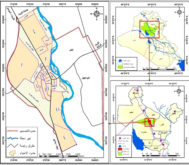
Map (1): Location of the Study Area in Relation to Iraq and Saladin Governorate (2024).
Source: Based on: The Administrative Map of Iraq (Scale 1:1,000,000); The Map of Saladin Governorate (Scale 1:250,000); and Tikrit Municipality Directorate / Technical Department: The Master Plan Map of Tikrit for the years 1983 and 2010.
First: The 2010 Update of Tikrit’s Master Plan
The primary objective behind updating Tikrit’s master plan in 2010 was to expand land allocations and enhance urban land-use patterns by fully utilizing all available spaces within the planning boundaries. This update focused on introducing new urban functions, including residential, commercial, industrial, and service sectors, alongside infrastructure development and the improvement of transport and road networks.
The residential sector received the largest share of these allocations, with land parcels distributed to meet the needs of various social groups, particularly public employees and the families of martyrs and the wounded. This expansion manifested clearly in the southern and western districts, such as Al-Dyum and Shishin, as well as in the northern neighborhoods adjacent to Tikrit University, including Al-Qadisiyah and Al-Jamia. The preparation of this update was based on comprehensive field surveys and studies, following a technical and planning methodology implemented by the Tikrit Municipality Directorate in cooperation with the Directorate of Urban Planning. Map (1) illustrates the updated 2010 master plan boundaries, which accommodated the population surge and facilitated urban growth across various parts of the city.
Historically, Tikrit’s planning relied on the 1983 master plan developed by the firm "Weidleplan," which subsequently underwent a thorough revision in 2010 to address demographic growth and urban sprawl. The update maintained the external boundaries of the original design, stretching from the Tigris River in the east to the Baghdad–Mosul Highway in the west, and from Wadi Shishin in the south to the Tikrit University borders in the north. This project was executed by an engineering and technical team from the Tikrit Municipality Directorate in collaboration with the Directorate of Urban Planning. This update resulted in a significant increase in urban land-use area, rising from 2,520 hectares to 5,090 hectares—a shift that reflects the scale of urban expansion witnessed by the city, as demonstrated by the comparisons in Table (1) and Figure (1).
Table (1): Variations in Urban Land-Use Areas Between 1983 and 2010 within the Updated Master Plan.
|
Urban Parameters |
1983 Master Plan |
2010 Updated Master Plan |
Amount of Increase |
|
Total Area (Hectares) |
8,970 |
10,260 |
1,290 |
|
Urban Land Use (Hectares) |
2,520 |
5,090 |
2,570 |
|
Urban Land Use Percentage(%) |
28.1 |
49.6 |
21.5 |
Source: Based on data from:
Ministry of Planning, Urban Planning Commission, Directorate of Urban Planning in Saladin Governorate, (Unpublished Data), 2024.
Directorate of Municipalities in Saladin Governorate, Tikrit Municipality Directorate, City Planning Department, (Unpublished Data), 2024.
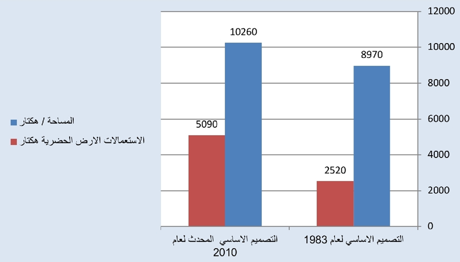
Figure (1): Variations in Urban Land-Use Areas Between 1983 and 2010 within the Updated Master Plan.
Source: Based on Table (1).
Table (1) and Figure (1) illustrate the variations in urban land-use areas between 1983 and 2010, revealing distinct spatial shifts in the land-use structure within the city of Tikrit. The total area of the master plan increased from 8,970 hectares in 1983 to 10,260 hectares in 2010—an expansion of 1,290 hectares. This growth reflects the enlargement of the city's boundaries and the integration of new urban zones within the updated planning framework.
At the level of urban land-use specifically, the city witnessed a substantial and remarkable increase; the area dedicated to urban uses rose from 2,520 hectares to 5,090 hectares during the same period. This increase of 2,570 hectares signifies a clear acceleration in the urbanization process and urban sprawl at the expense of other land-use categories, indicating a significant transformation in the city’s spatial structure toward a predominantly urban character.
Furthermore, this expansion is clearly reflected in the proportion of urban land use relative to the total master plan area, which climbed from 28.1% in 1983 to 49.6% in 2010—a net increase of 21.5%. This shift serves as a critical indicator of the changing function of land within the city and the growing dominance of urban uses compared to non-urban uses. Such a transition is a direct consequence of population growth and the expansion of residential and service-related activities, which necessitated the reorganization of urban space and the extension of the city's reach in multiple directions under the updated master plan.
Second: Predicting Spatial and Urban Expansion Trends in Tikrit Using Geospatial Artificial Intelligence (GeoAI)
In recent years, the city of Tikrit has undergone rapid spatial transformations in urban land-use and land-cover patterns. These shifts are clearly reflected in the city’s spatial and urban expansion trajectories, creating a need for analytical tools capable of deciphering urban growth dynamics and planning future pathways with high scientific and objective precision. Consequently, this study utilizes Geospatial Artificial Intelligence (GeoAI) as an advanced framework for analyzing and predicting spatial changes. This is achieved by integrating the Google Earth Engine (GEE) platform—which allows for the highly efficient processing and analysis of massive geospatial datasets—with the CA-Markov model. The latter combines the characteristics of Cellular Automata (CA) in representing local spatial interactions with the probabilistic modeling of Markov Chains to characterize temporal change trends in land use (Ibrahim & Obaid, 2021, p. 497). This integration facilitates a realistic simulation of urban expansion mechanisms within their specific spatial and temporal contexts.
The study relies on land-use and land-cover (LULC) data for the period 2000–2024, sourced from the Global Land Cover (GLC-FCS30D) database with a spatial resolution of 30 meters, chosen for its temporal continuity and suitability for urban analysis. This data was reclassified into four primary categories: Urban Areas, Agricultural Lands, Water Bodies, and Barren Lands. The objective of this classification is to streamline analytical procedures, enhance the clarity of major spatial transformations, and bolster the model’s explanatory power. In this regard, a set of spatial variables influencing future spatial and urban expansion was prepared, including Euclidean distance maps from roads and rivers, alongside elevation and slope layers derived from the Shuttle Radar Topography Mission (SRM) Digital Elevation Model (DEM), given their direct role in guiding urban growth patterns.
Based on these inputs, an urban expansion map for Tikrit for the year 2024 was extracted. Subsequently, predictive scenarios for spatial expansion were constructed for the years 2034 and 2044. This provides a forward-looking reading of the city’s urban and spatial trajectory and allows for an assessment of its potential spatial implications. This approach represents an advanced applied framework for utilizing GeoAI techniques in studying urban expansion, contributing a future spatial vision that can be employed to support sustainable urban planning policies and land-use management within the city.
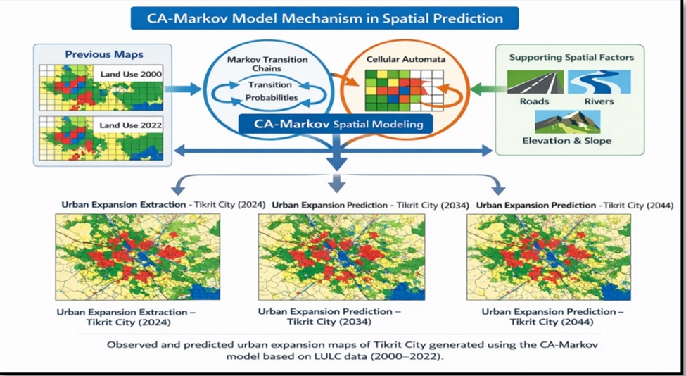
Figure (2): The Mechanism for Predicting Spatial and Urban Expansion in the Study Area for the Period (2024–2044).
Source: Based on: CA-Markov model and data from the Global Human Settlement Layer (GHSL): https://human-settlement.emergency.copernicus.eu/GHSWUPDownload.php?ds=WUPDEGURBA
Figure (2) illustrates the operational mechanism of the CA-Markov model in spatially predicting the urban and spatial expansion of Tikrit. This is achieved through an integrated approach that links the temporal dimension with spatial interaction and the various determinants of urban growth. The land-use and land-cover (LULC) maps for the years 2000–2024 serve as the primary inputs for the model, depicting historical spatial transitions. These maps allow for the extraction of transformation trends between different land categories, such as the conversion of agricultural or barren lands into urban zones.
The analysis then transitions to Markov Chain probabilities, where a transition probability matrix is calculated based on the changes observed between the two time periods. This component addresses the temporal aspect of change (i.e., when and with what probability change occurs) without precisely determining its spatial location. Subsequently, the Cellular Automata (CA) component addresses the spatial dimension of change based on the principle of spatial proximity. Each spatial cell is influenced by the state of its neighboring cells, enabling a simulation of gradual and realistic expansion that mirrors real-world urban sprawl.
The CA-Markov model integrates the probabilistic results of the Markov Chain with the rules of Cellular Automata, while incorporating the auxiliary spatial variables shown on the right side of Figure (2)—specifically proximity to roads and rivers, as well as elevation and slope. These factors guide expansion toward areas most suitable for urban development while reducing the probability of growth in topographically or environmentally unsuitable regions. The final outputs of the model yield the 2024 urban expansion map as the current state, followed by the generation of predictive maps for 2034 and 2044. These maps represent potential future scenarios for urban growth, outlining the trajectories of spatial extension and the increasing urban footprint at the expense of other land uses. Overall, the figure reflects the logical sequence of the CA-Markov model: beginning with historical analysis, moving through the dynamics of change, and concluding with future forecasting.
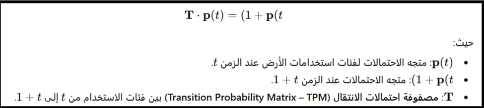
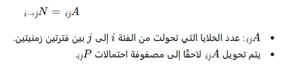
The application of the Markov model was based on the following equations:
- State Update Equation in the Markov Model:
2- Definition of the Transition Probability Matrix Elements:

3-Transition Area Matrix:
4-Iterative Conditional Distribution Probability (Chapman-Kolmogorov Equation):
Spatial and Urban Expansion of Tikrit (2024–2044):
Tikrit stands as an urban model experiencing continuous growth driven by population increases, the expansion of service-related activities, and improvements in transport and communication networks. This dynamic necessitates a focused study on urban expansion trends for the period (2024–2044). Such a timeframe allows for a comprehensive analysis of the current urban state, followed by the development of future scenarios that outline potential expansion trajectories influenced by a range of spatial, environmental, and human factors.
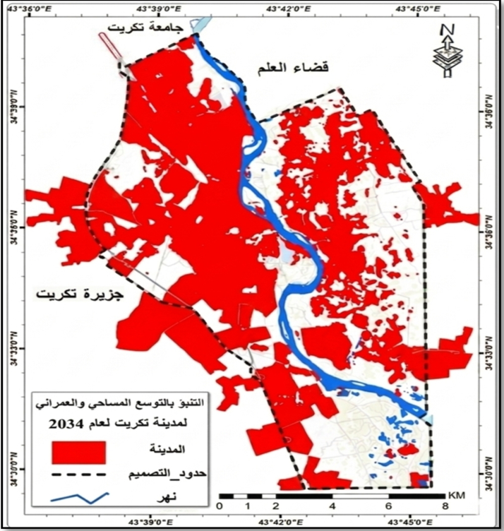
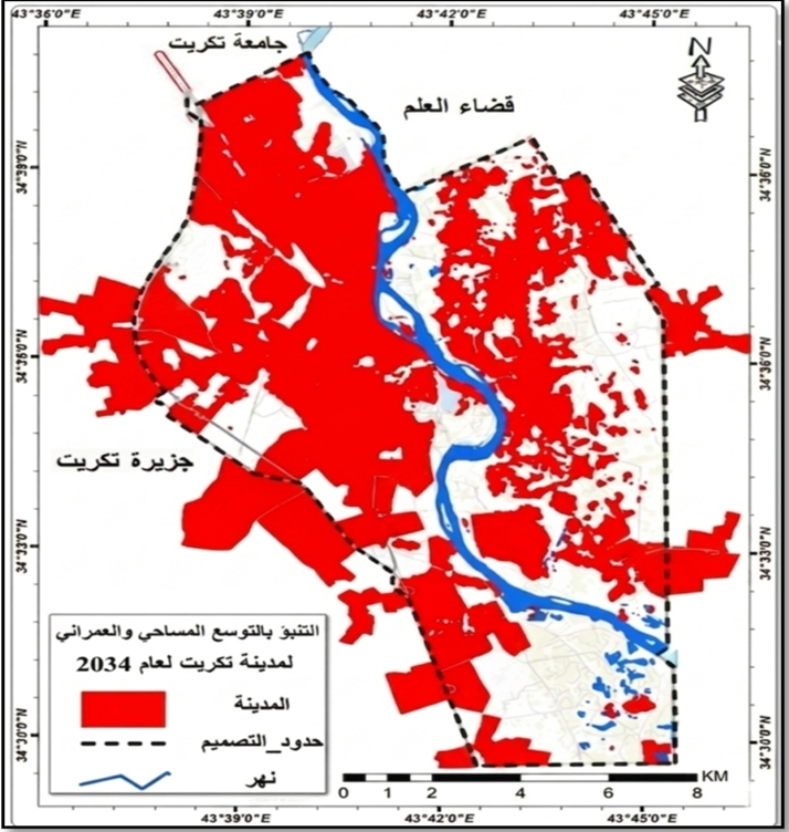
This section relies on modeling Tikrit's spatial and urban expansion using Geospatial Artificial Intelligence (GeoAI) techniques and spatial predictive models. The objective is to provide a precise future vision of urban growth trends, thereby supporting sustainable urban planning and guiding spatial development toward optimal land use within the city over the coming decades. Maps (2), (3), and (4), along with Table (2), illustrate the findings regarding the spatial and urban expansion of Tikrit for the period (2024–2044).
Table (2): Spatial and Urban Expansion of Tikrit (2024–2044).
|
Year |
Area (KM^2) |
|
2024 |
38.5 |
|
2034 |
52.2 |
|
2044 |
61.8 |
Source: Based on the Markov Predictive Model and ArcMap software.
Table (2), which illustrates the spatial and urban expansion of Tikrit for the period (2024–2044), reveals a clear upward trend in the city's urban footprint. This reflects a continuous and accelerating pace of urban growth over the coming decades. In 2024, the urban area is approximately 38.5 km^2, representing the current state of urban expansion based on existing spatial data. This area is projected to rise to 52.2 km^2 by 2034—an increase of 13.7 km^2 within a single decade. Such growth indicates a significant acceleration in urban sprawl toward the city's peripheries, driven by the increasing demand for residential and service-related land.
By 2044, the urban area is expected to reach 61.8 km^2. While this confirms the ongoing upward trajectory, the pace is relatively slower compared to the previous decade, suggesting a more stabilized expansion pattern as the built-up mass approaches its natural and planning boundaries. This cumulative growth in urban area indicates that Tikrit is gradually reshaping its spatial structure, expanding into surrounding lands, particularly in directions with higher developmental potential.
This transformation demonstrates that urban growth in Tikrit over the future period is not occurring randomly; rather, it follows a gradual spatial pattern linked to urban attraction factors such as road networks, infrastructure, and the availability of land suitable for expansion. These findings underscore the vital importance of integrating predictive modeling tools into urban planning processes to ensure that such growth is managed with greater efficiency and sustainability.
Map (2): Spatial and Urban Expansion of Tikrit in 2024.
Source: Based on ArcMap software.
Map (3): Predicting Spatial and Urban Expansion of Tikrit for the Year 2034.
Source: Based on the Markov Predictive Model and ArcMap software.
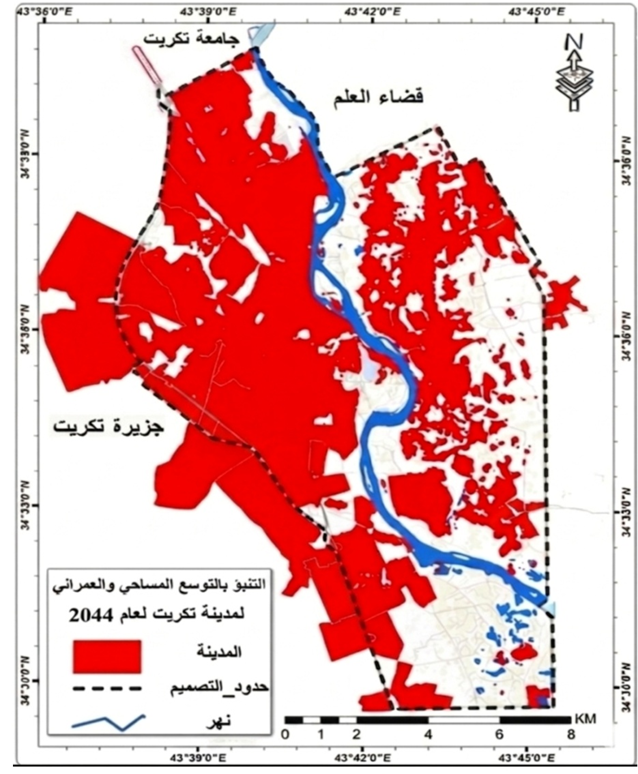
Map (4): Predicting Spatial and Urban Expansion of Tikrit for the Year 2044.
Source: Based on the Markov Predictive Model and ArcMap software.
Through the analysis of Maps (2, 3, and 4), specifically for the years 2024, 2034, and 2044, it is observed that the predicted spatial and urban expansion trends for Tikrit are primarily directed toward the North, Northwest, and West of the current city, following the trajectory of the Baghdad-Mosul Highway. This direction reflects a clear spatial pattern of urban mass expansion, which aligns significantly with the city's current reality and population movement trends, as these areas are the most suitable for actual urban growth.
This trend is attributed to several spatial and urban factors, most notably the absence of natural or human constraints, the availability of state-owned land suitable for development, and the strategic connection of these directions to the primary road network, which facilitates accessibility and connectivity to the city center for service and commercial purposes. Consequently, future planning for Tikrit necessitates a revision of the city’s current Master Plan, expanding it to harmonize with actual population growth trends and needs, thereby achieving balanced and sustainable urban
development.
CONCLUSION :
The study results indicate that Tikrit has experienced significant urban expansion throughout the study period. The urban area rose from 38.5 km^2 in 2024 to 52.2 km^2 in 2034, reaching 61.8 km^2 by 2044. This total increase of 23.3 km^2 reflects continuous and accelerating urban growth during the prediction period.
The study demonstrated that the urban expansion rate recorded a cumulative growth of approximately 60.5% between 2024 and 2044. This serves as a clear indicator of the city's transition toward intensive urbanization and increasing pressure on surrounding lands.
Results regarding the Master Plan updates showed that the area allocated for urban uses increased from 2,520 hectares in 1983 to 5,090 hectares in 2010—an increase of 2,570 hectares. This growth rate reached 21.5% of the city's total area, reflecting the rapid urbanization witnessed during that phase.
Spatial modeling results confirmed that future urban expansion trends in Tikrit are primarily directed toward the North, Northwest, and West. This is due to the availability of developable land and its strategic connectivity to the primary road network.
The integration of Geospatial Artificial Intelligence (GeoAI) with the CA-Markov model proved highly efficient in analyzing spatial changes and predicting urban expansion by producing accurate maps for future growth scenarios.
The study revealed that urban expansion in Tikrit does not occur randomly; rather, it is influenced by a set of spatial factors such as roads, transportation, and topography. This underscores the necessity of incorporating predictive models into future urban planning processes.
Recommendations
It is essential to adopt the results of predictive modeling when updating the Master Plan for Tikrit, ensuring it aligns with future urban growth trends.
Geospatial Artificial Intelligence (GeoAI) techniques and the CA-Markov model should be extensively utilized in urban planning studies for other Iraqi cities.
Urban expansion should be directed toward areas that are environmentally and spatially most suitable, while minimizing pressure on agricultural lands.
A continuously updated geospatial database for Tikrit must be developed, including periodic land-use monitoring to support informed planning decisions.
Advanced spatial analysis should be integrated into the operations of local planning institutions to ensure more efficient management of urban growth and the achievement of sustainable development.
BIBLIOGRAPHY:
1. -Ibrahim, S. T., & Obeid, M. K. (2021). Using the Digital Terrain Model (DTM) to Represent the Population Density Map of Kirkuk City. Journal of the College of Basic Education for Educational and Humanitarian Sciences, University of Babylon, Issue 52, Par2-Hamad, R. (2018). Predicting land use/land cover changes using a CA-Markov model under two different scenarios. Sustainability, 10(10), 3421. https://doi.org/10.3390/su10103421
2. -Hamad, R. (2018). Predicting land use/land cover changes using a CA-Markov model under two different scenarios. Sustainability, 10(10), 3421. https://doi.org/10.3390/su1010342
3. -Taloor, A. K., Sharma, S., Parsad, G., & Jasrotia, R. (2024). Land use land cover simulations using integrated CA-Markov model in the Tawi Basin. Geographical and Environmental Modeling, Elsevier. https://doi.org/10.1016/j.geogeo.2024.100268
4. -Mondal, M. S., Sharma, N., & Garg, P. K. (2016). Statistical independence test and validation of CA-Markov LULC prediction results. Egyptian Journal of Remote Sensing and Space Science. https://doi.org/10.1016/j.ejrs.2016.08.001
5. -Eastman, J. R. (2012). IDRISI Selva: Tutorial on CA-Markov and transition probability matrices for LULC change modeling.
6. -Asif, M. (2023). Modelling of land use and land cover changes and prediction using CA-Markov. Taylor & Francis. https://doi.org/10.1080/10106049.2023.2210532t 2, Volume 13.